


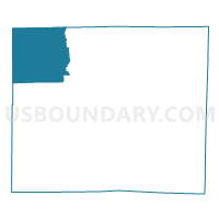
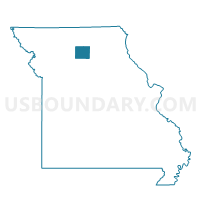
Jackson Voting District, Linn County, Missouri
About
Outline

Summary
| Unique Area Identifier | 608991 |
| Name | Jackson Voting District |
| County | Linn County |
| State | Missouri |
| Area (square miles) | 56.24 |
| Land Area (square miles) | 55.90 |
| Water Area (square miles) | 0.34 |
| % of Land Area | 99.40 |
| % of Water Area | 0.60 |
| Latitude of the Internal Point | 39.97619430 |
| Longtitude of the Internal Point | -93.29770580 |
Maps

Graphs
Select a template below for downloading or customizing gragh for Jackson Voting District, Linn County, Missouri


Neighbors
Neighoring Voting District (by Name) Neighboring Voting District on the Map
- Benton North Voting District, Linn County, MO
- Benton South Voting District, Linn County, MO
- Browning Voting District, Sullivan County, MO
- Clay Voting District, Linn County, MO
- Locust Creek Voting District, Linn County, MO
- Medicine Voting District, Livingston County, MO
- Taylor Voting District, Sullivan County, MO
- Wilson Voting District, Grundy County, MO
Top 10 Neighboring County Subdivision (by Population) Neighboring County Subdivision on the Map
- Locust Creek township, Linn County, MO (544)
- Benton township, Linn County, MO (508)
- Wilson township, Grundy County, MO (406)
- Duncan township, Sullivan County, MO (385)
- Clay township, Linn County, MO (248)
- Jackson township, Linn County, MO (173)
- Medicine township, Livingston County, MO (164)
- Taylor township, Sullivan County, MO (98)
Top 10 Neighboring Elementary School District (by Population) Neighboring Elementary School District on the Map
Top 10 Neighboring Unified School District (by Population) Neighboring Unified School District on the Map
- Chillicothe R-II School District, MO (12,889)
- Linn County R-I School District, MO (1,580)
- Meadville R-IV School District, MO (1,279)
- Grundy County R-V School District, MO (1,040)
Top 10 Neighboring State Legislative District Lower Chamber (by Population) Neighboring State Legislative District Lower Chamber on the Map
- State House District 3, MO (35,529)
- State House District 7, MO (34,548)
- State House District 8, MO (33,540)
Top 10 Neighboring State Legislative District Upper Chamber (by Population) Neighboring State Legislative District Upper Chamber on the Map
Top 10 Neighboring 111th Congressional District (by Population) Neighboring 111th Congressional District on the Map
Top 10 Neighboring Census Tract (by Population) Neighboring Census Tract on the Map
- Census Tract 4801, Livingston County, MO (3,652)
- Census Tract 4902, Linn County, MO (2,300)
- Census Tract 9601, Grundy County, MO (2,124)
- Census Tract 4802, Sullivan County, MO (1,579)
Top 10 Neighboring 5-Digit ZIP Code Tabulation Area (by Population) Neighboring 5-Digit ZIP Code Tabulation Area on the Map
- 64653, MO (687)
- 64630, MO (602)
- 64688, MO (548)
- 64635, MO (515)
- 64652, MO (441)
- 64674, MO (428)
- 64646, MO (297)